
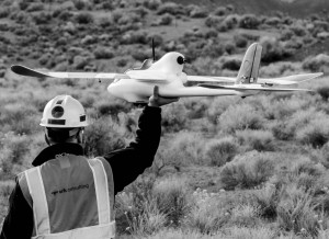
A former co-worker of mine and long time friend sent out an email last week showing off the results of a project he’s been working on. This project combines two of Warren’s hobbies: Flying model airplanes and hacking (programming) things. [Not sure why he couldn’t find someway to incorporate a drum kit into the mix?]
Adam Radel & Warren Medernach of SRK Consulting have developed a system for capturing high quality imagery from a remote-controlled (RC) airplane. This UAS system they have developed can capture images with horizontal ground resolutions of up to four centimeters and elevation surface data with vertical ground accuracy of up to 10 cm
UAS defined in wikipedia…
“Uninhabited (or Unmanned) Aircraft Systems (UAS) Technology is an unmanned aerial vehicle (UAV), commonly known as drone, is an aircraft without a human pilot on board. Its flight is controlled either autonomously by computers in the vehicle or under the remote control of a pilot on the ground or in another vehicle.”
The data captured can be used by SRK to produce high quality, very informative topographical maps and 3D surface models. The key here is that compared to existing systems this is a much lower cost, quicker to deploy, and its very safe. Take a look at some of the samples they have posted, it is very impressive!
[subscribe2]


