One of the things that I manage is the flow of data between engineering projects and the field. Once the overall control points are established, there is not a lot of survey network information coming back in. Construction crew and RTK point data is delivered simply as a delimited ascii file. So what good does the Autodesk Civil 3D Survey Database do for me if all I have is raw coordinates?
Shared, controlled data. You can use it to share that point data with numerous team members, and manage it from one location. It’s like a low rent Data Reference…for points.
Distribution
 Let’s say you have a region that is going to get a lot of attention. You can master the site control gathered from existing survey(s), and everyone can pull their information from one true remote source. As new information is added, the database is updated accordingly.
Other benefits can be attained when numerous people are working on a large project with separate sites. The point data can be pulled down from the master database, and surfaces and location information can then be developed without concern that “You didn’t get the newest data”. When updates come through, the network gets flagged with an update, subsequently everyone receives the same update when things have been changed.
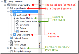
- Create a Database for an overall region, selecting an easy network path to point everyone to
- Create an associated network within the Database to add the data to. Separate site activity may go to separate networks
- Add data from sources such as Civil 3D drawings and ascii files
- Open my planning drawing, right click the Survey Points, and add points to the drawing.
 That’s all there is to it. Everyone can access the data simultaneously.
As each dataset is imported, each session is logged as an Import Event, with various information including the source file path. One of the options available in the database is to re-import individual Import Events. This makes data adjustments easy to manage. The database automatically adjusts the related points, leaving you without concerns of damaging associated data.
This morning a technician complained that his data was way off target. A quick check showed that the data I was furnished was measured in meters. I adjusted the data, and had the database re-import the logged Import Event. Immediately following, the technician (and everyone else) was able to update his drawing with the new data.
Import Events
Occasionally is is useful to master the data in a set of drawings. If you foresee a lot of point adjustments or evaluation on the horizon, you can import each “Import Event” into a Civil 3D drawing first. Then when you are happy with the result, create a new Import Event, and use the import “Points from Drawing” option.
Inserting Points into Drawings
 Points can be referenced from only a specific network, or from the entire database. Any item in the Survey Database that is titled with “…Points” will permit those respective points to be inserted into the drawing. The entire Database, a-la-carte, and right down to a single point. Additionally, these same points can be removed from the drawing through the same context menu, or they can be erased manually. Either option does not matter because they have no effect on the database.

- When the points are inserted, Civil 3D points are created as representations of the Database contents. Their layer, style, appearance etc can be adjusted, but the point information is locked. You can’t even move a point.
![]()
- I bet that got some folks attention. That’s right, Civil 3D point data inserted from the Database cannot be modified by the user….but it can be modified by the database.
What that means is that when the Database is adjusted, the points can be instructed to follow suit.

Read Only and Edit
The Database only allows on user to be logged in with edit rights, and provides read only access to all the others. I assign one technician to carry out the edits, and all others know to log in as read only.
Some Essentials
 One essential item I will mention is a standardized Description Key file. Points inserted to a Civil 3D drawing are pulled through the Description Keys (if so configured). Having a consistent file for all project members keeps things neat and tidy.
Make sure whatever Datums and Unit settings associated with the projects are all set appropriately. If the Database is set to International Feet, and the Drawings are set to US Survey Feet, you WILL be screwed.
Comments
This tool isn’t only for balanced traverses and huge control networks, and doesn’t have to be used as it was advertised. It can be used any way you like. It doesn’t matter whether you have 100 points or 10000 points, if you want to share them with different users, you might consider the Civil 3D Survey Database. It can provide secure, remote sharing of data that spans numerous projects from one convenient location.
