DWG TrueView Crashes While Publishing PDF
We noticed Autodesk DWG TrueView 2024 crashes while the Vault Job Processor was publishing PDF and...
Read More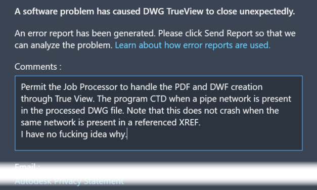
We noticed Autodesk DWG TrueView 2024 crashes while the Vault Job Processor was publishing PDF and...
Read More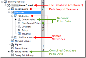
One of the things that I manage is the flow of data between engineering projects and the field....
Read MoreThis will be another quick tip, for those new to the Civil 3D platform and using TDS. We used to...
Read MoreI mess with a lot of points. Incoming and outgoing. One things we can’t seem to do, is to...
Read MoreThis is old news, but I was having too much fun not to post it. I have a big building pad with...
Read MoreCivil 3D 2010 Update 1 cleared up the Point Label style block issue that had plagued many of us. Kind of a relief, I have been hesitant to edit ANY Label Styles, since being tortured by the problem. Just the knee jerk reaction...
Read More7/29/2009 Transferring Civil entities by ‘Write Block’ has always been tricky. We used to...
Read MoreI logged a Bug Report on Civil3D.com, and you can check it out HERE. I wanted to thank James...
Read More6/12/2009 Life without strife would be boring. It’s the occasional issues that give the good...
Read MoreI posted this Civil 3D Point Style tip on Civil3D.com. Check it out.
Read MoreVery often people run into problems when their Points lose their controls. The label...
Read MoreOk, this isn’t rocket science, but some people don’t know about this. If you want to assign a...
Read More